CCI.Maps

Connect information. Streamline processes.
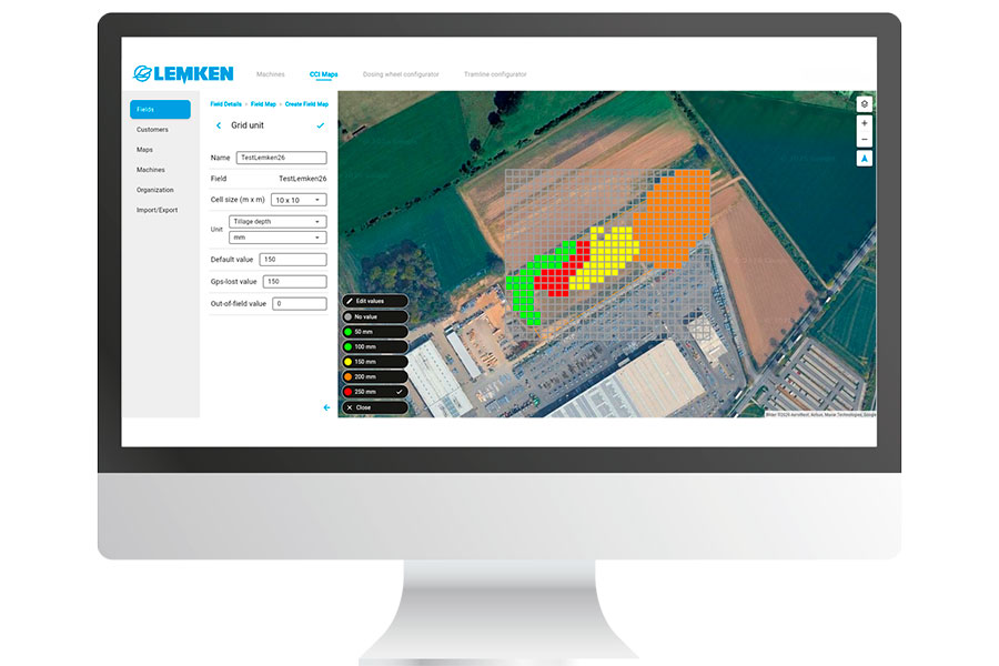
CCI.Maps is the central platform for the digital management of machine, telemetry, and field data. It helps farmers collect and manage information in a structured way and make it available where it is needed—in the office, on the terminal, or directly in the field. By connecting data and work processes, CCI.Maps lays the foundation for modern and efficient data management.
Your benefits at a glance
- Consistent access to up-to-date information
- Real-time synchronization between the office, the terminal, and the machine
- Simple and intuitive user interface
- Cross-software field boundary management
All relevant data in one place
Everyday farm operations generate a wealth of information about fields, machines, and work processes. CCI.Maps consolidates this data into a single platform, ensuring it is always available. This allows users to maintain a clear overview of their operations and efficiently manage, share, and process information.
Connected from the office to the field
With CCI.Maps, you can manage your fields digitally, generate application maps, store information centrally, and access it at any time—even from home or the office. This saves time, reduces errors, and provides a better overview of your operation. Users can access up-to-date data at any time via the iQblue go app or the web application and keep track of their operations. Application maps can be easily imported into CCI.Maps and exported as ISOXML files for use on the terminal. Thanks to centralized data management, information is maintained only once and is subsequently available at all relevant locations.